The price of speed
The need for speed devours huge chunks of American cities and leaves the edges of the expressways worthless. Busy streets, for almost all of human history, created the greatest real estate value because they delivered customers and clients to the businesses operating there. This in turn cultivated the highest tax revenues in town, both from higher property taxes and from elevated sales taxes. But you can't set up shop on the side of an expressway. How can cities afford to spend so much to create thoroughfares with no adjoining property value?
Let's first look at the four basic problems with speed:
Curves
Increasing speed a little bit requires a big increase in the size of curves. At 20 miles per hour, any car can handle a curve with a 15 foot radius, so you'd think that tripling the speed would triple the radius, right? Wrong. At 60 miles per hour, curve radii are usually a few hundred feet, not the 45 feet you might guess.
Lane Width
Faster roads need wider lanes. An 8 foot lane can handle 20 mile per hour traffic, but at highway speeds, you need 12 foot lanes.
Medians and shoulders
High-speed roads need wide medians and shoulders because a car can roll hundreds of feet beyond the point of collision or loss of control when it is traveling at highway speeds.
Number of lanes
It makes no sense to use all that land on either side for a two-lane highway, so high-speed thoroughfares usually have at least four lanes, often several more.
Florence vs. Atlanta Interchange
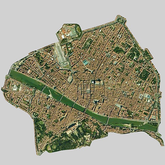
Florence, Italy
Look at Florence above… the blocks are tiny, and the streets are never much more than hairlines. From this high up in the sky, the intersections look like sharp right angles. This is because Florence was laid out for people and horses, which can turn on a dime. Cars drive on these streets today, but they drive slowly, which is far safer for the pedestrians.
The Atlanta interstates are each as wide as 2-3 blocks of Florence. The entire Duomo (the cathedral in the center of Florence that arguably began the Renaissance) could fit in one of the inner loops of the interchange, as you can clearly see. The central core of Florence, from the Duomo to the river, would fit inside the inner box of the interchange. The world was irreversibly changed by the people living and working in Florence who gave birth to the Renaissance. The interchange will never change the world… at best, it gets a small fraction of Atlanta workers to their jobs a bit sooner, barring any accidents.
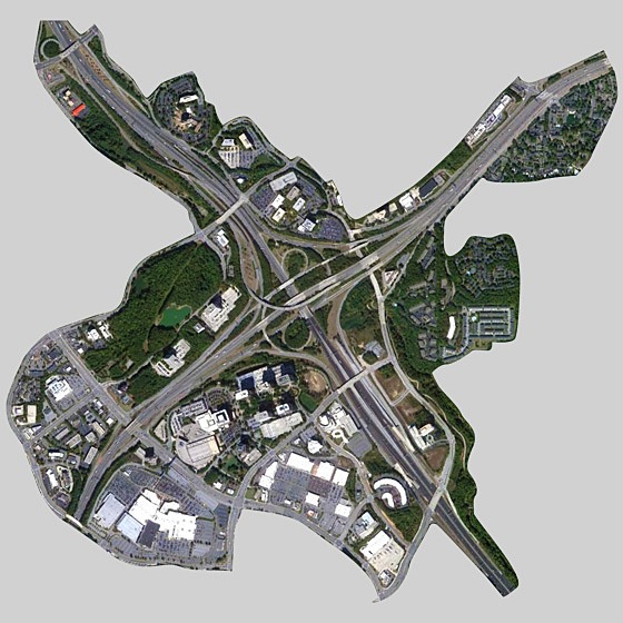
Atlanta interchange
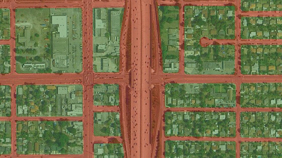
Seaside vs. Miami: A closer look
Let's analyze this at a larger scale. Each of the following two images is a half-mile wide and contains 90 acres of land or sea. The first is , which as you may know is the birthplace of the New Urbanism. Its fabric is not so different from the scale of neighborhoods we built everywhere in the US before World War II. The second image is an urban interchange along Interstate 95 just north of downtown Miami. I selected this location because the urbanism is relatively tight here, and the curves are minimal. I could have picked something further out in suburbia that was looser, but that would be like shooting fish in a barrel.
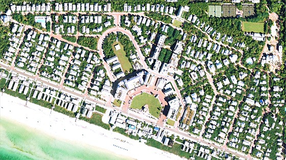
Seaside, Florida (same scale as I-95 in Miami)
Looking at these images, it's immediately clear that there's a lot more paving in the Miami image than in Seaside. But if you start counting blocks, you'll see that there are 27 blocks of urbanism in Seaside (even though 13 acres in the lower left corner is lost to beach and sea) while there are only 15 blocks in the Miami image, depending on what you consider a block. That gives us a pretty good hint that maybe there's more real estate value above than below.
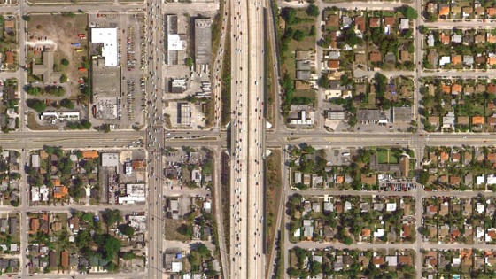
I-95 in Miami, Florida (same scale as Seaside)
The speed burden: Land area
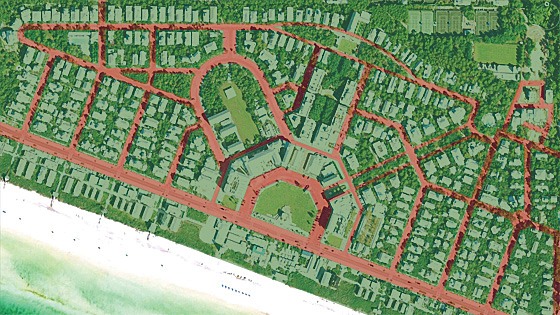
green land: has real estate value ~ red land: no real estate value
One measure of land value is acreage. In Seaside, 80.5% of the available land has real estate value; only 19.5% of the land is taken up in thoroughfares. Note that I have included parks, greens, squares, and plazas as having real estate value even though they cannot be sold because studies have clearly shown that open these types of natural spaces create more real estate value in nearby lots than if they had been sold as private lots.
Only 62.6% of the land in the Miami example has any real estate value because the thoroughfares consume 37.4% of the land. Based on Seaside, it would be reasonable to say that about 20% of the land in a traditional neighborhood should be allocated to thoroughfares. The Miami example consumes almost twice as much: 37.4%/20%-1 = an 87% Acreage Speed Burden. How can we afford to burden the land with 87% more thoroughfare acreage than necessary for a vibrant walkable environment?
green land: has real estate value ~ red land: no real estate value
The Speed Burden - Frontages
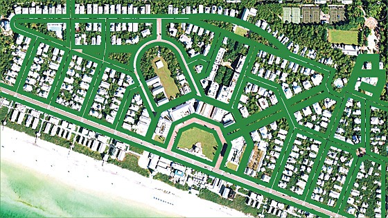
green frontages: full value
Acreage isn't the only metric of land value. The "front foot," or length of the front property line is another metric of real estate value that is perhaps more useful than acreage. In Seaside, every single foot of frontage is full value, meaning that it either has addresses of private lots along it, or it opens into parks, greens, squares, and plazas. Even though only 77 of the 90 acres are buildable (the rest being beach and sea) Seaside has generated 36,200 feet of full-value frontage.
The Miami example doesn't fare nearly so well. The frontages along the I-95 and its exit ramps have no value at all. Even if you wanted to open up a shop there, it's illegal to do so. There are 9,531 feet (almost two miles) of worthless frontages here. Some of the frontages are shown as "partial value." These are frontages that are either 100% side streets (no front doors) or frontages that have been ruined with big parking lots just behind the sidewalk. There are 6,303 feet of partial-value frontages in this image. That leaves 17,820 feet of full-value frontage, for a total of 33,654 feet of frontage of all types. Interestingly, Seaside generated a half-mile more frontage on 13 less buildable acres, and all of it is full-value, whereas only 52.9% of the Miami frontage is full-value. So even if Seaside had built as much on the full 90 acres instead of the 77 buildable acres, that would still be a 47.1% Speed Burden based on full-value frontages.
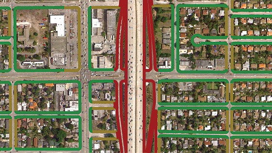
green frontages: full value ~ olive frontages: partial value ~ red frontages: worthless
How can we afford to pay so much and get so little? Cities really do need to rethink their infrastructure priorities. We are beyond the point where we can spend enormous sums of money with little or no return. Municipalities, from cities to towns, villages, and hamlets, all need to take a careful look in the mirror each time they want to spend money and ask themselves: "What is the return on this investment?"
Note: This post is part of an extended on Return on Investment (RoI) of municipal spending. Hazel Borys started the BlogOff with the following post… please join us!
1/27/12 - , Hazel Borys
Another Note: This is part of an occasional series on the costs of sprawl I started in March 2011 with . Lots more to come… hopefully more quickly next time.
Steve Mouzon is principal of an architecture and urban design firm, based in Miami Beach, Florida, and author of The Original Green, book and
For more in-depth coverage on this topic:
• to Better! Cities & Towns to read all of the articles (print+online) on implementation of greener, stronger, cities and towns.
• See the of New Urban News. Wall Street and urbanism, streets to plazas, Sustainable Communities grants, Choice Neighborhoods, TIGER grants, buyers prefer smart growth, protecting historic buildings, public health and planning, redevelopment in Georgia, Ecovillages, parklets
• Get , packed with more than 800 informative photos, plans, tables, and other illustrations, this book is the best single guide to implementing better cities and towns.
Comments