The problem with Walk Score
How walkscore.com labels asphalt wastelands "highly walkable."
Launched in 2007, Walk Score has been revolutionary in many ways. The website provides a walkability rating of zero to 100 for any address in the US, and is now used extensively for academic research, to help allocate affordable housing tax credits, and by the real estate industry for sales and investment.
A lot rides upon the accuracy of , which rates walkability based on how many services and amenities are within walking distance. "Walk Score also measures pedestrian friendliness by analyzing population density and road metrics such as block length and intersection density," according to a description on the Walk Score site.
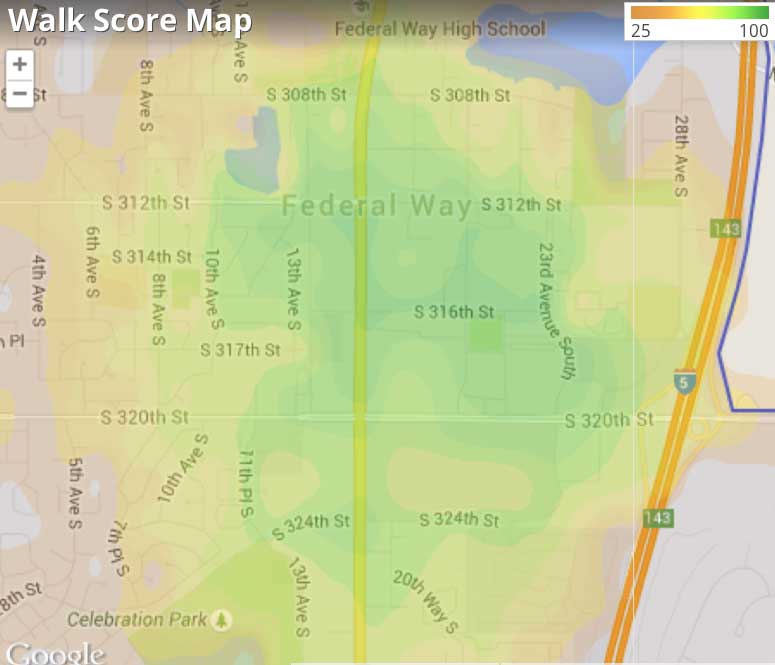
For most purposes, it seems to work fairly well. The cities with the highest Walk Score ratings—New York, San Francisco, Boston, Philadelphia—are indeed the most walkable. While looking up Walk Scores recently, I came across a curiosity—a place that was identified as highly walkable within a drive-only suburban area. Such areas appear as green blobs or blotches. Zooming in, I expected to find a historic town. Instead, I found big box stores and "power centers" in a sea of asphalt.
Here's the Walk Score map that I was looking at.
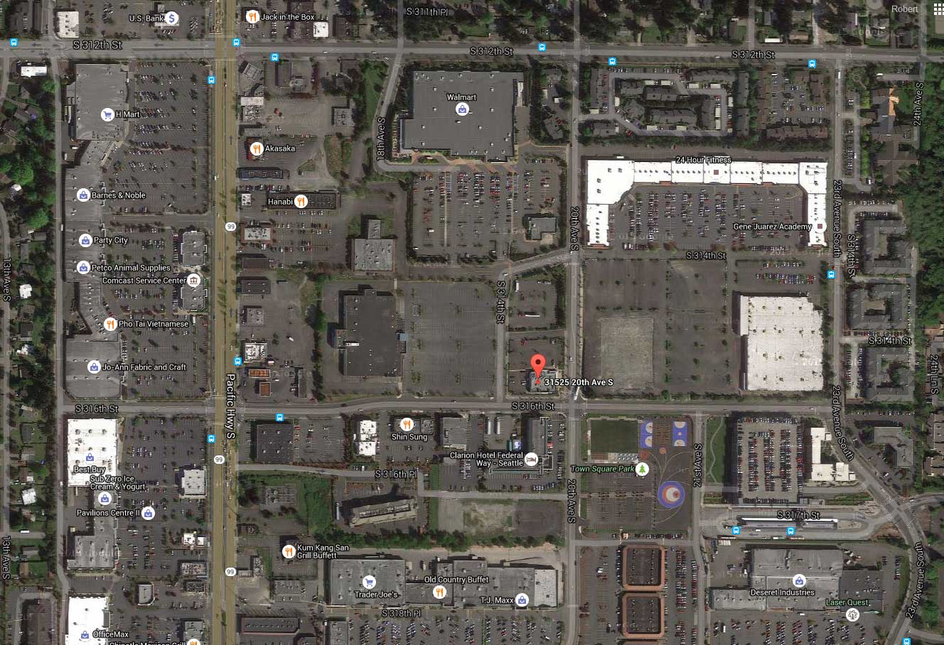
Below is an aerial image of the area from Google—it's mostly surface parking, big box commercial buildings, and large roads.
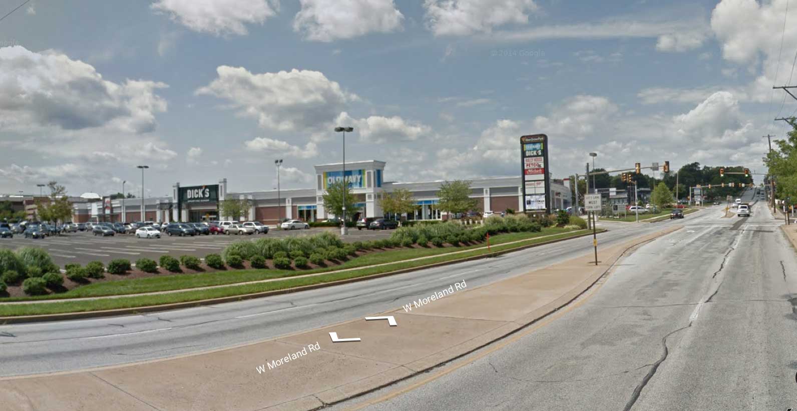
Here's the Google street view of the site.
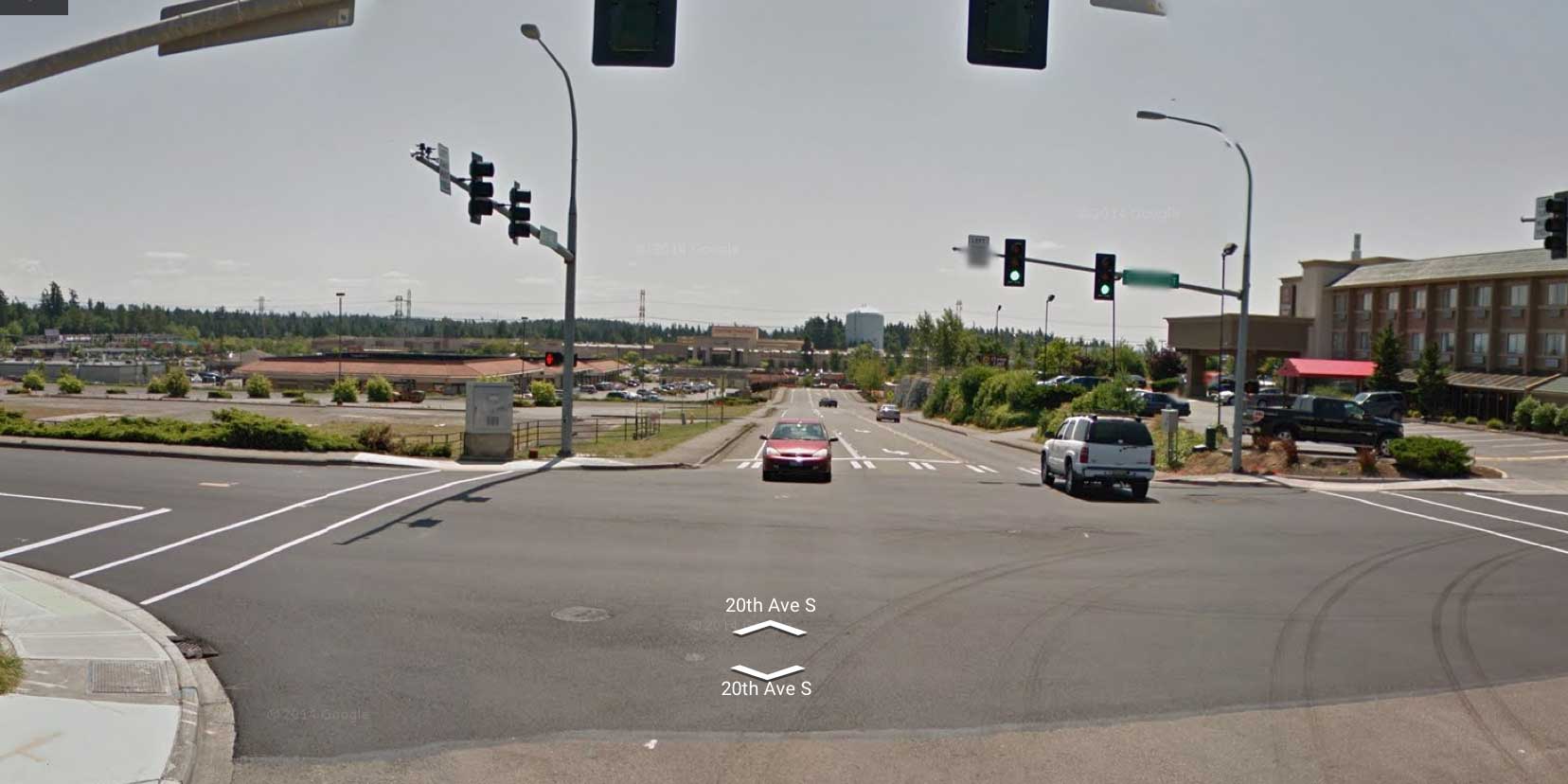
Federal Way, Washington, an outer suburb of Seattle, was incorporated in 1990 from sprawling subdivisions and commercial areas. This particular spot, 20th Avenue South, near the city's Walmart, will never be confused with San Francisco—but apparently Walk Score is confused. This site is given a score of 87 ("very walkable"—most errands can be accomplished on foot). For comparison, the City of Boston has an average Walk Score of 80 and San Francisco gets an 84.
The problem is that Federal Way doesn't have any truly walkable downtown or neighborhood that I can find. Few people will be getting around on foot in that particular spot any time soon—unless they are desperate. The average block size in the area is 14 acres (from the ), which is far too large to support a human-scale urban place. By comparison, average block sizes in downtown Seattle are 2 acres.
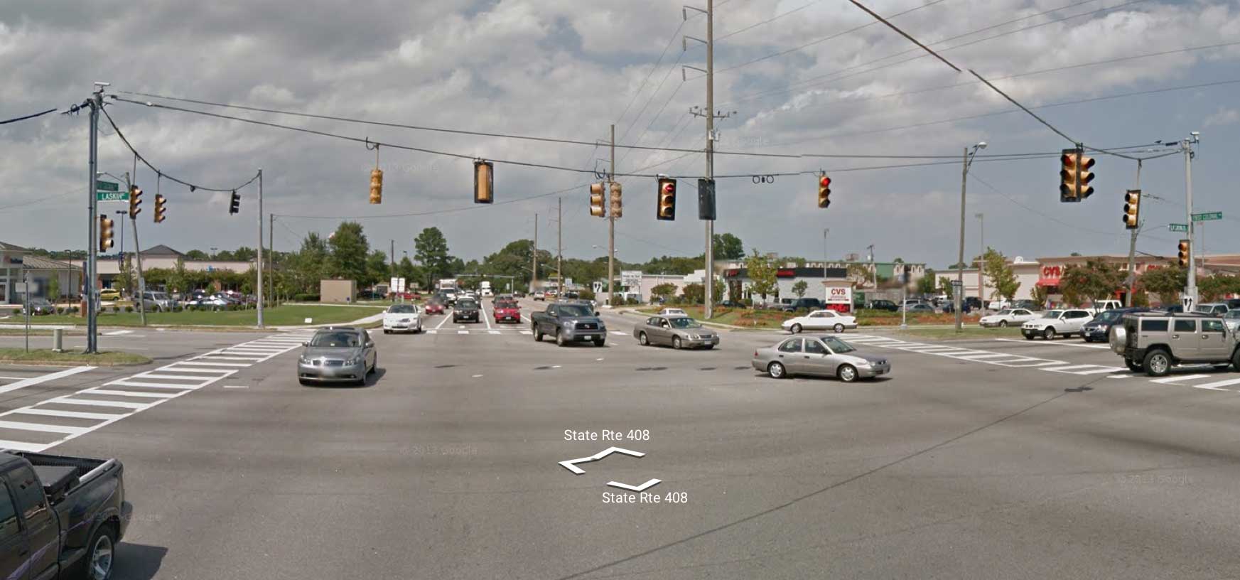
The area has sidewalks, but the distances to houses are large and people would have to traverse boring, pedestrian-repellent spaces. After discovering that location in Federal Way, I easily found other suburban places where, essentially, no-walk zones get high Walk Scores. The image at the top of the article is from Laskin Road in Virginia Beach, an intersection with a Walk Score of 77—also called "very walkable." Would you walk there? This intersection is easily 100 feet across and drivers routinely top 50 miles per hour—I've driven Laskin Road many times. Maybe that's why no pedestrian is visible in this—or any of these—photos.
Below is an address in Willow Grove, Pennsylvania, which received a Walk Score of 82.
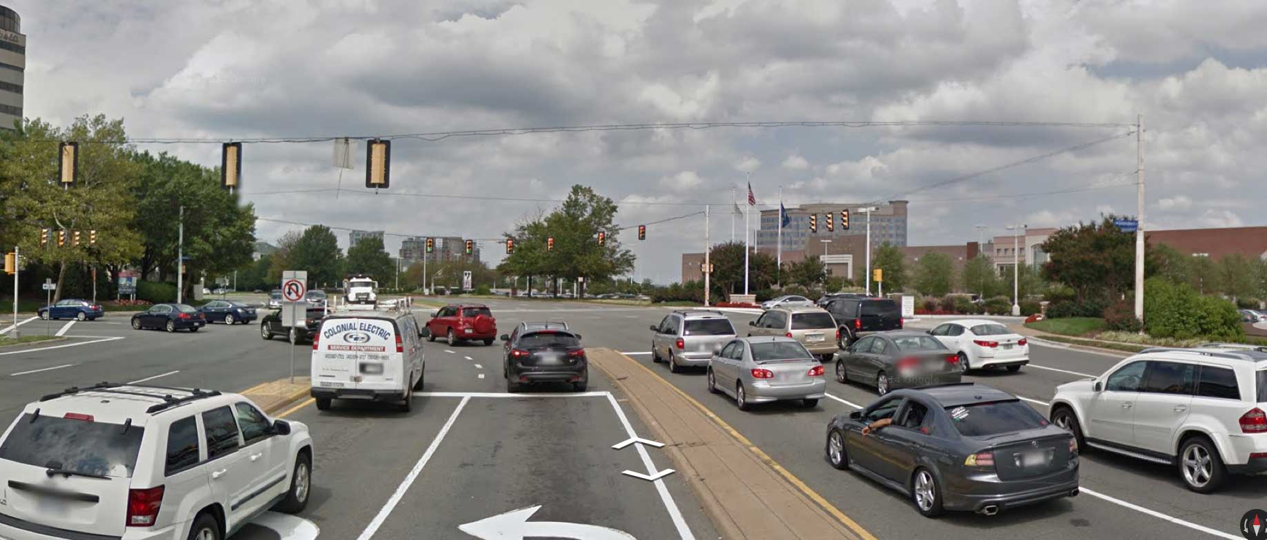
This location on Tysons Corner, Virginia, gets a Walk Score of 72, "very walkable." Crossing this would be scary.
I don't think any site should be called "very walkable" if I wouldn't allow my 10-year-old to walk there. These sites have the characteristics that I call Big Asphalt. They are designed for high-volume, high-speed, traffic—with a ton of parking, mostly in surface lots. Although they score wall on Walk Score, they are not truly diverse relative to an urban neighborhood or downtown.
Federal Way scores well on grocery stores, eating and drinking establishments, errands (services), shopping, and schools. Looking more closely at schools, however, reveals problems with online data sources. The closest "school" has no students and is probably an educational office of some kind. It is not to be confused with a public high school or elementary school, but it scores the same on Walk Score. Real schools are located a half mile to a mile away, but how many children would walk to and from this place? A park is nearby, but it has plenty of parking and most people will likely arrive there by car.
Apartments can be found a quarter mile to the east and single-family houses sit a quarter mile the west. To walk from the apartments to a house would require a miserable half-mile trek past vast parking lots and across intersections designed for fast traffic.
My conclusion is that Walk Score has a problem. It may work reasonably well in historic cities and towns and at the municipal scale. But it can be way off in suburban commercial districts. Federal Way, as a whole, has a Walk Score of 36—"car dependent." Judging by the scores in Federal Way's commercial district, even that score may be too high.
Walk Score needs to recalibrate its system. The site could solve this problem if greater weight was given to intersection density or block size. An area with 14-acre blocks should never get a high Walk Score—because that's a sure sign that a place not walkable.
If Walk Score does not improve its system, perhaps a competing site should be established that does the job better. In the meantime, researchers and investors should be aware of this flaw in Walk Score.
Robert Steuteville is editor and executive director of Better Cities & Towns.
Comments